Use multiple risk sources
Sea-Level Rise, Flood, Storm-Surge, and Erosion Research
Learn how to compare official flood maps, sea-level scenarios, storm surge, coastal change, historical events, and insurance information for a property.
The short answer
No single map answers every property-risk question. FEMA maps primarily support floodplain management and insurance administration; NOAA and USGS tools can add sea-level, high-tide, surge, shoreline, and coastal-change context. Local drainage, elevation, building condition, and insurance underwriting still require property-specific research.
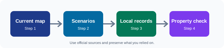
Address-level research method
Confirm the exact location
Record the street address, parcel number, coordinates if available, jurisdiction, watershed, and coastal or river setting.
Open the effective flood map
Save the map panel, zone, effective date, and any letters or amendments relevant to the parcel.
Add scenario and event context
Review sea-level, storm-surge, erosion, rainfall, and historical-event sources without treating scenarios as exact predictions.
Ask local questions
Contact floodplain, planning, building, public works, emergency management, and utility offices about drainage, access, projects, and rules.
Test financial resilience
Ask insurers and qualified professionals how the exact location and structure affect coverage, deductibles, mitigation, and repair feasibility.
Map-reading record
- Tool, agency, URL, layer, scenario, and date viewed
- Address or parcel searched and any geocoding correction
- Map limitations and resolution
- Current regulation versus future scenario clearly labeled
- Screenshots or exported reports with source information
- Questions requiring local or professional verification
Print or save this list. Add dates and source information so you can tell what was known at each decision point.
Independent tools and authoritative starting points
FEMA Flood Map Service Center
View official flood maps and related products for an address or community.
NOAA Sea Level Rise Viewer
Explore scenario-based coastal inundation, vulnerability, and high-tide flooding information.
NOAA Digital Coast
Find coastal data, mapping tools, training, and resilience resources.
National Hurricane Center storm surge resources
Understand storm surge hazards and official forecast products.
USGS Coastal Change Hazards Portal
Review coastal change, shoreline, erosion, and storm-impact science.
NOAA Storm Events Database
Research recorded storms and significant weather events by place and date.
FEMA resilience analysis and planning tool
Compare community-level natural-hazard risk indicators and expected annual loss estimates.
Third-party notice: yPrivateAI is not affiliated with or endorsed by the third-party websites listed here. These links are starting points for independent research. Listings, availability, prices, property descriptions, maps, programs, and terms may change. Verify the property, representative, ownership, title, hazards, insurance availability, and payment instructions independently before making a commitment or transferring funds.
Related Moving On resources
Keep the recovery record together
Preserve notices, estimates, maps, quotes, receipts, listings, and the sources behind each important decision. For related documentation guidance, visit the property-damage documentation checklist and the policyholder resource library.